About All Tours UTV and ATV ToursFrom Las Vegas ToursHalf Day ToursPrivate Tours Directions Hours & Fees
Find Tours 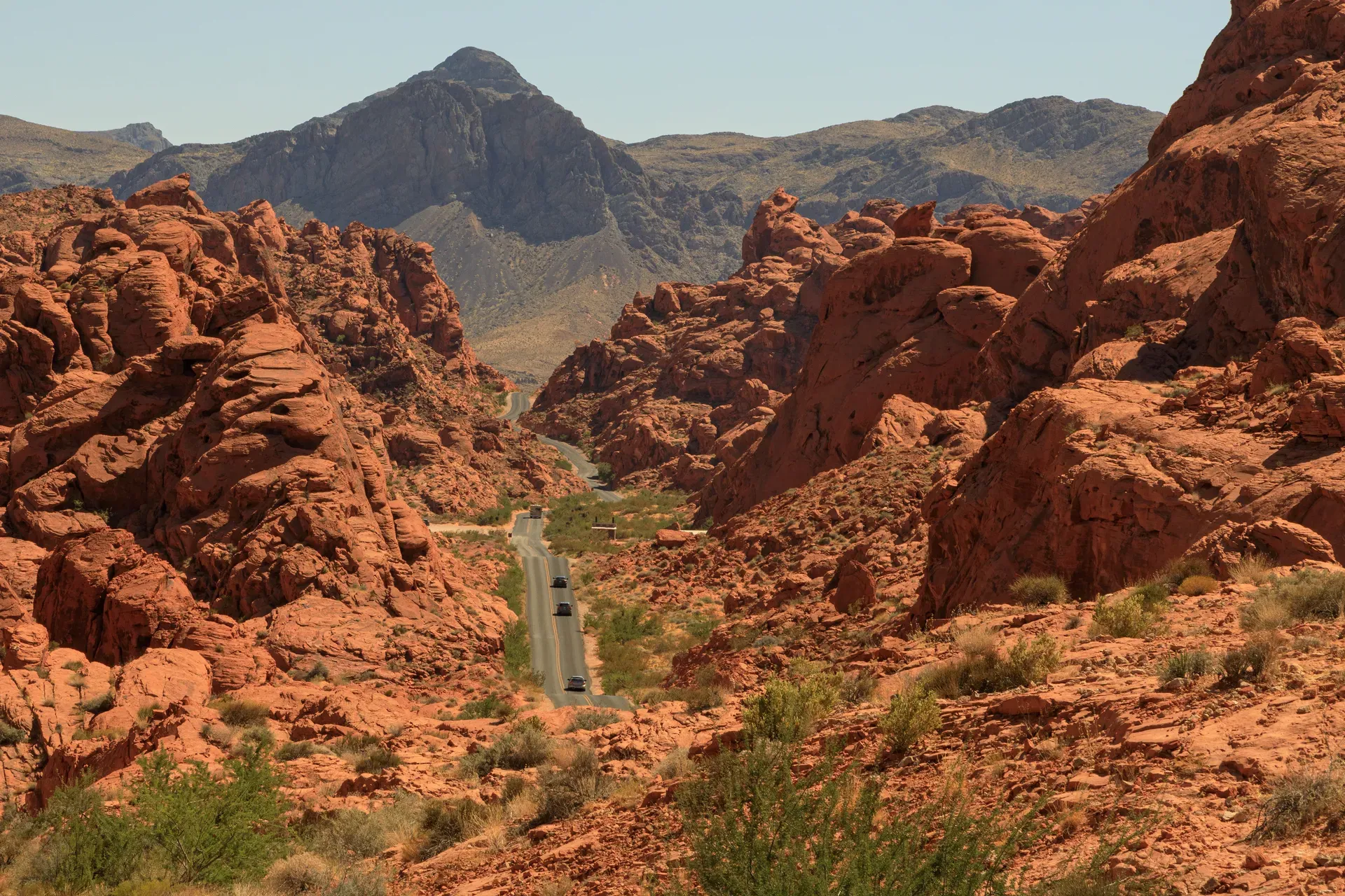
Valley of Fire State Park covers nearly 46,000 acres of bright red Aztec sandstone 50 miles northeast of Las Vegas. The landscape preserves 2,000-year-old petroglyphs and 150-million-year-old dunes within the Mojave Desert.
Valley of Fire State Park spans 46,000 acres of the Mojave Desert, defined by 40,000 acres of bright red Aztec sandstone outcroppings. These massive formations sit inside a 4-by-6-mile basin of gray and tan limestone mountains, exactly 50 miles northeast of the Las Vegas Strip. The eastern boundary abuts the Lake Mead National Recreation Area near the Virgin River confluence. The park operates 365 days a year from sunrise to sunset, drawing nearly one million annual visitors to its paved scenic drives and sandy trailheads.
Temperatures dictate how you experience the landscape. Winter highs hover around 75 degrees Fahrenheit, creating safe conditions for hiking the 1.5-mile Fire Wave trail or the 1.1-mile White Domes loop. Summer heat regularly exceeds 120 degrees Fahrenheit. Park rangers strictly enforce seasonal trail closures beginning May 15 for paths like Pastel Canyon, Prospect, and Pinnacles to prevent heat-related fatalities. Visitors arriving between May and September should limit their exploration to the air-conditioned, $30-million Visitor Center and vehicle pullouts along the main highway.
Cellular service drops to zero across most of the basin. You must download offline maps before leaving Interstate 15. Rideshare apps like Uber and Lyft will drop you off but cannot be summoned for a return trip, leaving unprepared travelers stranded. Bring exact cash if you plan to arrive after 4:00 p.m. when the fee booths close. Self-pay envelopes require $10 for Nevada residents or $15 for out-of-state vehicles, while walk-in or bicycle visitors pay $2 per person.

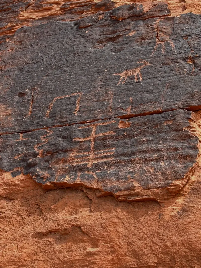
Human activity in the Moapa Valley region dates back 11,000 years. The Basketmaker culture established a presence 2,500 years ago, leaving behind the first rock carvings on the canyon walls. Ancestral Puebloans occupied the basin from 300 BC to 1150 AD, farming nearby areas and using the sandstone valleys for hunting and religious ceremonies. They carved the atlatl—a prehistoric throwing stick used before the bow and arrow—into the high rock faces. You can view these exact 2,000-year-old petroglyphs today by climbing a steep metal staircase at Atlatl Rock.
A rough dirt road cut through the basin in 1912. This route formed part of the Arrowhead Trail, an early highway connecting Salt Lake City to Los Angeles. During the 1920s, an official from the American Automobile Association drove through the area at sunset. The fading light hit the red sandstone, prompting him to name the basin the "Valley of Fire." The federal government later recognized the area's geological value, designating it a National Natural Landmark in 1968.
The Civilian Conservation Corps arrived in 1933 to build the first permanent facilities. Workers constructed stone cabins, campgrounds, and improved roads using local materials. The park opened to the public on Easter Sunday in 1934, drawing 9,000 visitors in its first year. The Nevada State Legislature officially designated it as the state's first park in 1935. Today, the park maintains 73 campsites across two campgrounds. Administrators enforce a strict two-week maintenance closure from December 1 through December 14 every year to preserve the infrastructure.
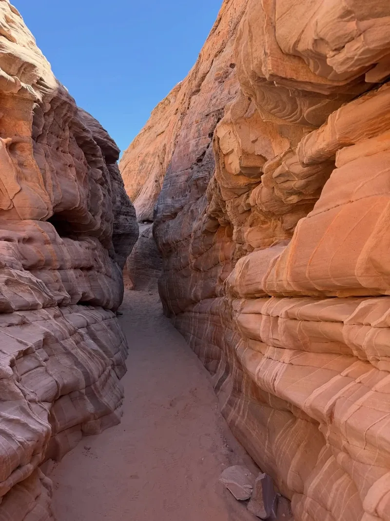
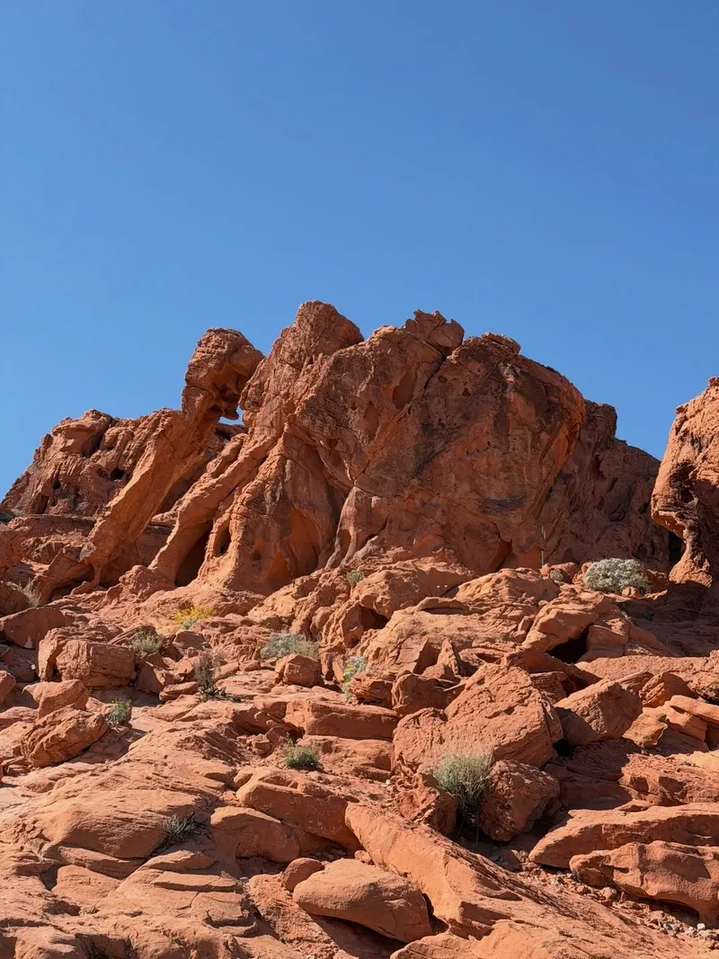
Aztec Sandstone dominates the 4-by-6-mile basin. These formations originated 150 million years ago during the Jurassic period, formed from massive shifting sand dunes that eventually petrified. Iron oxide gives the rock its intense red, orange, and pink coloring. Over millennia, wind and water eroded the stone into distinct shapes. You can observe a delicate arch resembling an elephant near the East Entrance, or walk across swirling, wave-like patterns of white and orange stone on the 1.5-mile Fire Wave trail.
The red sandstone sits on a foundation of much older Paleozoic limestone. These gray and tan mountains date back 250 to 550 million years. They contain fossilized marine life, including algae, trilobites, and corals, left behind by an ancient shallow sea that once covered the Mojave Desert. The contrast between the brilliant white and red sandstone against the gray limestone creates sharp visual boundaries. Hikers experience this geological shift directly inside the narrow slot canyons of the White Domes loop.
Desert vegetation clings to the sandy soil between the rock formations at elevations ranging from 1,320 to 3,009 feet. Creosote bush, burro bush, and brittlebush cover the valley floor, alongside beaver tail and cholla cacti. The park supports a population of desert bighorn sheep, which navigate the steep sandstone cliffs, and desert tortoises that shelter from the extreme heat. Africanized honey bees also inhabit the area. These aggressive insects constantly seek water, requiring campers to keep their sites completely dry and store all liquids inside vehicles.
The red sandstone walls function as an ancient historical record. Basketmaker and Early Pueblo cultures carved thousands of petroglyphs into the rock faces over 2,000 years ago. These carvings depict hunting scenes, local wildlife, and geometric patterns. The densest concentrations appear along the 0.75-mile Mouse's Tank trail and high on the walls of Atlatl Rock. State and federal laws protect these artifacts. Park rangers issue heavy citations to anyone touching the art, climbing restricted formations, or adding modern graffiti.
The landscape holds deep ties to the Southern Paiute people. The natural rock basin known as Mouse's Tank takes its name from a Southern Paiute outlaw who used the area's complex canyon system to hide from authorities in the 1890s. The nearby Lost City Museum in Overton, located 16 miles away, houses artifacts recovered from the Ancestral Puebloan settlements. These farming communities once bordered the park before the construction of the Hoover Dam flooded the adjacent valleys to create Lake Mead.
Commercial media frequently utilizes the park's distinct red rocks to simulate alien planets or prehistoric landscapes. Film crews must secure permits, pay a $100 daily reservation fee, and provide liability insurance 30 days in advance. Drones remain strictly banned to protect daily helicopter tours and local wildlife. Visitors attempting to fly unauthorized drones face immediate confiscation and fines.
The $30-million Visitor Center features a 10-minute orientation film narrated by actor William Shatner.
The park is home to aggressive Africanized bees that actively scout for open water sources at campsites.
Wind and water eroded a sandstone outcrop near the East Entrance to perfectly resemble an elephant walking.
The entire park shuts down completely for two weeks every December for annual maintenance.
Flying a drone is strictly prohibited and heavily fined to prevent interference with daily helicopter landings.
A natural rock basin holds rainwater for months and is named after an 1890s Southern Paiute outlaw who hid there.
The gray limestone mountains surrounding the red sandstone contain 500-million-year-old fossils of trilobites and corals.
The day-use entrance fee is $10.00 per vehicle for Nevada residents and $15.00 for out-of-state vehicles. Visitors entering on bicycles, horseback, or on foot pay $2.00 per person. Towed-in vehicles are exempt from these fees.
Yes. Park rangers close several popular trails, including the Fire Wave, White Domes, and Seven Wonders Loop, starting May 15 each year. These closures prevent life-threatening heat exhaustion when summer temperatures exceed 120 degrees Fahrenheit.
No. Drones and all remote-controlled aircraft are strictly prohibited within the park boundaries. You can only operate a drone if you secure an approved commercial photography permit at least 30 days in advance.
Pets are welcome in the park but must remain on a leash no longer than six feet at all times. You cannot bring dogs inside the Visitor Center.
Cellular service is extremely poor or nonexistent across the 46,000-acre park. You should download offline maps before arriving. Paid WiFi access is available at the Visitor Center and Atlatl Rock Campground.
Rock climbing is permitted in most areas, but it is strictly banned on Arch Rock, Elephant Rock, and Atlatl Rock to protect fragile geology and ancient petroglyphs. Rappelling requires prior authorization from the Park Supervisor and is restricted to the Lone Rock area.
The park operates two campgrounds with a combined total of 73 sites. Some sites include RV power and water hookups. You must reserve all campsites in advance through the Nevada State Parks reservation website.
Valley of Fire State Park opens daily from sunrise to sunset, 365 days a year. The Visitor Center operates from 9:00 a.m. to 4:00 p.m. daily.
Metal detectors are strictly prohibited. State and federal laws protect all historical artifacts, rocks, and minerals within the park. Removing or disturbing any natural or cultural resources is illegal.
The West Entrance Station is located approximately 50 miles northeast of the Las Vegas Strip. The drive takes about one hour via Interstate 15 North and the Valley of Fire Highway.
Browse verified tours with free cancellation and instant confirmation.
Find Tours